
Berkas:Indonesia location map.svg

Ukuran pratayang PNG ini dari berkas SVG ini: 800 x 307 piksel resolusi uweewo:320 x 123 piksel | 640 x 245 piksel | 1.024 x 393 piksel | 1.280 x 491 piksel | 2.560 x 981 piksel | 1.200 x 460 piksel
Berkas asli (Berkas SGV, nominal 1.200 x 460 piksel, damango berkas:739 KB)
Limbu'o
| Deskripsi |
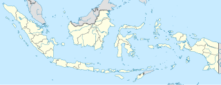
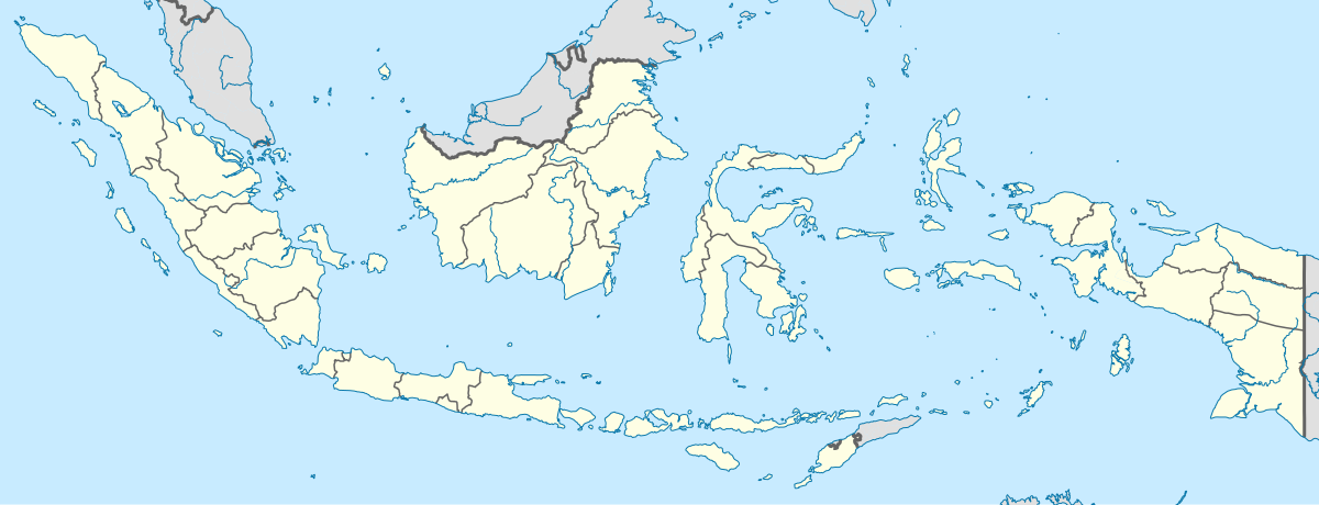
English: Location map of Indonesia.
Equirectangular projection. Stretched by 100.0%. Geographic limits of the map:
|
| Tanggal | |
| Bungo | Ilomata lo hihilawo |
| Ta ohu'uwo | Uwe Dedering |
| Versi lainnya |
|
Tayadu lisensi
Saya, pemilik hak cipta dari karya ini, dengan ini menerbitkan berkas ini di bawah ketentuan berikut:
Berkas botiye pilopolisensi wolo lisensi Creative Commons Atribusi-BerbagiSerupa 3.0 Tanpa Adaptasi
- Yi'o mowali
- mopotayadu – mohemi wawu mopotayadu karaja botiye to nga'amila rupa
- Adaptasi – monguba, moromba wawu mohutu mali uweewo lonto berkas botiye
- Payu buto'o botiya
- atribusi – Yi'o musti moluladu tanggulo u banari mongohi wumbuta wolo lisensi, wawu mopolele ma yilomoli'o.
Yi'o mowali mohutu woloolo u otohilamu, dabo jamowali mopolele ta longohi lisensi akoro wolemu meyalo u pilohutumu.
- Mopotayadu odelo odiye – Wonu Yi'o moromba, momoli'o meyalo mohutu uweewo lo materi botiye, Yi'o musti mopololadu kontribusi olemu to walungo same or compatible license wolo materi asli.

|
Mowali mohemi, mopotayadu wawu/meyalo momoli'a dokumen botiye wolo syarat-syarat Lisensi Dokumentasi Bebas GNU, Versi 1.2 atau lebih baru yang diterbitkan oleh Free Software Foundation; tanpa Bagian Invarian, tanpa Teks Sampul Depan, dan tanpa Teks Sampul Belakang. Salinan lisensi dimasukkan ke bagian yang berjudul Lisensi Dokumentasi Bebas GNU. |
Yi'o mowali molulawoto lisensi otohilamu
Riwāyati lo berkas
Klik to tanggal/wakutu momilohe berkas to saa'ati botiye.
| Tanggal/Wakutu | Gambari kiki'o | Dimensi | Ta ohu'uwo | Lo'iya | |
|---|---|---|---|---|---|
| baharu | 4 Desember 2022 23.54 | 1.200 × 460 (739 KB) | NordNordWest | upd | |
| 3 Juli 2022 04.17 | 1.200 × 460 (910 KB) | NordNordWest | upd | ||
| 27 Juni 2013 04.21 | 1.200 × 460 (854 KB) | NordNordWest | upd | ||
| 18 Pebruari 2010 20.58 | 1.200 × 460 (1,2 MB) | Uwe Dedering | {{Information |Description={{en|1=Location map of Indonesia. Equirectangular projection. Strechted by 100.0%. Geographic limits of the map: * N: 6.5° N * S: -11.5° N * W: 94.5° E * E: 141.5° E Made with Natural Earth. Free vector and raster map |
Berkas u pilopohuna
6 halaman botiya lopohuna berkas:
Pilopohuna berkas global
Wiki uweewo hemomake berkas botiya
- Pilopohuna to ace.wikipedia.org
- Pilopohuna to af.wikipedia.org
- Pilopohuna to als.wikipedia.org
- Pilopohuna to an.wikipedia.org
- Pilopohuna to ar.wikipedia.org
- Pilopohuna to ast.wikipedia.org
Bilohi ngohuntuwa ta lopohuna global lo berkas botiye.