
Berkas:Panama-Canal-rough-diagram-quick.jpg
Panama-Canal-rough-diagram-quick.jpg (560 x 540 piksel, tu'udu berkas:57 KB, MIME tipe: image/jpeg)
Limbu'o
| Deskripsi |
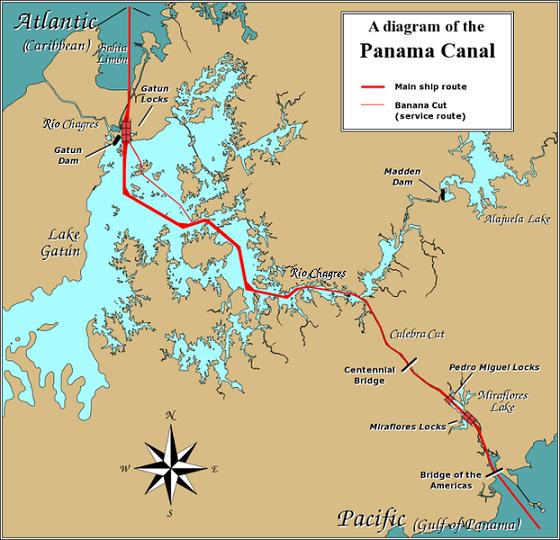
English: A diagram illustrating the layout of the Panama Canal (in quick JPEG format, auto-resizes to fit).
Due to the shape of the Isthmus of Panama, the Pacific end of the canal is actually the south-east end, and the Caribbean / Atlantic end is at the north-west. From the Pacific side, the Miraflores and Pedro Miguel locks (with two and one stages respectively) lead up to the highest level of the canal, 26 metres (85 feet) above sea level. The Culebra Cut (or Gaillard Cut) leads to Gatún Lake, created by damming the Chagres River; then the Gatún Locks lead back down to sea level in Limón Bay. The heavy red line shows the ship route. The narrower red line in Gatún Lake is the Banana Cut, a shortcut used by canal boats and yachts. |
| Tanggal | |
| Bungo | Source URL: Image:Panama_Canal_Rough_Diagram.png (GFDL file, reduced/retouched, saved JPEG format (5x faster than PNG), intended for use in frequently-read Wiki articles). |
| Ta ohu'uwo | User:Johantheghost (JPEG version by Wikid77) |


Tayadu lisensi

|
Mowali mohemi, mopotayadu wawu/meyalo momoli'a dokumen botiye wolo syarat-syarat Lisensi Dokumentasi Bebas GNU, Versi 1.2 atau lebih baru yang diterbitkan oleh Free Software Foundation; tanpa Bagian Invarian, tanpa Teks Sampul Depan, dan tanpa Teks Sampul Belakang. Salinan lisensi dimasukkan ke bagian yang berjudul Lisensi Dokumentasi Bebas GNU. |
| Berkas botiye pilopolisensi wolo lisensi Creative Commons Atribusi-BerbagiSerupa 3.0 Tanpa Adaptasi | ||
Yi'o mowali mohutu woloolo u otohilamu, dabo jamowali mopolele ta longohi lisensi akoro wolemu meyalo u pilohutumu.
| ||
| Label lisensi ini ditambahkan pada berkas sebagai bagian dari pemutakhiran lisensi GFDL. |
Riwāyati lo berkas
Klik to tanggal/wakutu momilohe berkas to saa'ati botiye.
| Tanggal/Wakutu | Gambari kiki'o | Dimensi | Ta ohu'uwo | Lo'iya | |
|---|---|---|---|---|---|
| baharu | 27 Desember 2006 01.28 | | 560 × 540 (57 KB) | Wikid77 | == Summary == A diagram illustrating the layout of the Panama Canal (in quick JPEG format, auto-resizes to fit). Due to the shape of the Isthmus of Panama, the Pacific |
Berkas u pilopohuna
Halaman botiya lopohuna berkas:
Pilopohuna berkas global
Wiki uweewo hemomake berkas botiya
- Pilopohuna to ar.wikipedia.org
- Pilopohuna to cdo.wikipedia.org
- Pilopohuna to cs.wikipedia.org
- Pilopohuna to de.wikipedia.org
- Pilopohuna to en.wikipedia.org
- Pilopohuna to es.wikipedia.org
- Pilopohuna to fi.wikipedia.org
- Pilopohuna to fr.wikipedia.org
- Pilopohuna to hu.wikipedia.org
- Pilopohuna to id.wikipedia.org
- Pilopohuna to jv.wikipedia.org
- Pilopohuna to km.wikipedia.org
- Pilopohuna to li.wikipedia.org
- Pilopohuna to map-bms.wikipedia.org
- Pilopohuna to min.wikipedia.org
- Pilopohuna to mn.wikipedia.org
- Pilopohuna to simple.wikipedia.org
- Pilopohuna to th.wikipedia.org
- Pilopohuna to ur.wikipedia.org
- Pilopohuna to vi.wikipedia.org
- Pilopohuna to www.wikidata.org
- Pilopohuna to zh.wikinews.org