
Berkas:Fiji location map.svg

Ukuran pratayang PNG ini dari berkas SVG ini: 467 x 599 piksel resolusi uweewo:187 x 240 piksel | 374 x 480 piksel | 599 x 768 piksel | 798 x 1.024 piksel | 1.596 x 2.048 piksel | 728 x 934 piksel
Berkas asli (Berkas SGV, nominal 728 x 934 piksel, damango berkas:144 KB)
Limbu'o
| Deskripsi |
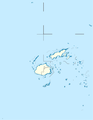
Deutsch: Positionskarte von Fidschi
Quadratische Plattkarte, N-S-Streckung 104 %. Geographische Begrenzung der Karte:
English: Location map of Fiji
Equirectangular projection, N/S stretching 104 %. Geographic limits of the map:
|
| Tanggal | |
| Bungo |
Ilomata lo hihilawo, using
|
| Ta ohu'uwo | NordNordWest |
| Ijini (Popohunawa ulangi berkas botiye) |
Saya, pemilik hak cipta dari karya ini, dengan ini menerbitkan berkas ini di bawah ketentuan berikut: Berkas botiye pilopolisensi wolo lisensi Creative Commons Atribusi-BerbagiSerupa 3.0 Tanpa Adaptasi
Yi'o mowali mohutu woloolo u otohilamu, dabo jamowali mopolele ta longohi lisensi akoro wolemu meyalo u pilohutumu.
|
| Versi lainnya |
Derivative works of this file: |


|
This map has been made or improved in the German Kartenwerkstatt (Map Lab). You can propose maps to improve as well.
|
Riwāyati lo berkas
Klik to tanggal/wakutu momilohe berkas to saa'ati botiye.
| Tanggal/Wakutu | Gambari kiki'o | Dimensi | Ta ohu'uwo | Lo'iya | |
|---|---|---|---|---|---|
| baharu | 19 September 2011 18.19 | | 728 × 934 (144 KB) | NordNordWest | corr |
| 12 Oktober 2009 00.04 |  | 728 × 934 (218 KB) | NordNordWest | {{int:filedesc}} {{Information |Description= {{de|Positionskarte von Fidschi}} Quadratische Plattkarte, N-S-Streckung 104 %. Geographische Begrenzung der Karte: * N: 12.3° S * S: 21.8° S * W: 174.4° O * O: 177.9° W {{en|Location map of |
Berkas u pilopohuna
Diya'a halaman u owumbuta ode berkas botiye
Pilopohuna berkas global
Wiki uweewo hemomake berkas botiya
- Pilopohuna to af.wikipedia.org
- Pilopohuna to an.wikipedia.org
- Pilopohuna to ar.wikipedia.org
- Pilopohuna to arz.wikipedia.org
- Pilopohuna to ast.wikipedia.org
- Pilopohuna to azb.wikipedia.org
- Pilopohuna to az.wikipedia.org
- Pilopohuna to ba.wikipedia.org
- Pilopohuna to be-tarask.wikipedia.org
- Pilopohuna to be.wikipedia.org
- Pilopohuna to bg.wikipedia.org
Bilohi ngohuntuwa ta lopohuna global lo berkas botiye.